Left Behind

Left Behind: A New Economics for Neglected Places

Paul Collier offers a compelling examination of global poverty. With a blend of academic depth and accessible writing, Collier explores the economic, social, and political factors perpetuating inequality. He argues for a nuanced approach to development, emphasizing investment in infrastructure, education, and governance. This thought-provoking book challenges conventional wisdom and advocates for tailored solutions to address the root causes of poverty. It’s a must-read for anyone interested in understanding and tackling the complexities of global development.

A Legacy of Segregation: Buffalo, NY’s Fruit Belt (Pt.3)

Urban Renewal 

An economic development tool, urban renewal was used by local governments across the country including the City of Buffalo. It was a method that was meant to economically revitalize areas through public investments that stimulated private development. What it actually translated to was the wholesale destruction of what were deemed blighted areas or slums, almost entirely based on racial composition. In their places often went new highways extending to the racially-restricted suburbs.[1]

City officials expected the removal of blighted areas would increase tax revenue for the City, revitalizing decay in the urban core, and improving living conditions for the poorest slum dwellers.[2] However, urban segregation is an ongoing social war in which the state meddles in the name of “progress,” “beautification,” and even “social justice for the poor” but ends up redrawing spatial boundaries to the advantage of landowners, foreign investors, elite homeowners, and middle-class commuters.[3] Overcrowded, unsanitary, dilapidated districts would be replaced by clean, modern housing projects and civic institutions. There are four urban renewal projects that impacted the Fruit Belt, three of which affected the neighborhood indirectly. 

Ellicott District & the Kensington Expressway

The Ellicott District was located in an area south of the Fruit Belt. In figure 3 the Fruit Belt is still census tract 31 and the Ellicott District is tract 24. It is clear from this map that as early as the 1930s the district was densely populated and segregated from the rest of the city. 

Figure 3: 1930s African American Population Density Map

The combination of limited capital, slumlords, and a still growing population meant that by the 1950s the neighborhood was one of the most densely populated and impoverished in the city. Citing the prevalence of substandard and unsanitary housing, overcrowding, and inadequate public utilities, the city’s planning commission decided to demolish significant portions of the Ellicott District. In 1951, the City Planning Commission published their General Plan for the City of Buffalo, which laid out how urban decay would be combated.[4] What would go in its place was meant to be a medium density residential neighborhood, public buildings, and public green spaces.[5] 

The project displaced African American households and, just a few blocks north of the neighborhood, the Fruit Belt was one of the places they resettled. As previously stated, this sudden influx of African Americans accelerated the already creeping exodus of Germans. Though many of the German families moved away, many homeowners retained their properties choosing to rent them out to incoming African Americans. This too led to social and housing issues, however, as many of the new, absentee landlords practiced price gouging and rented their small properties to multiple families. 

Then, in 1954, the City announced its plan to build the Kensington Expressway, a massive, expensive highway that would help people reach downtown Buffalo faster making the city more car friendly in the process. The Kensington Expressway replaced a major portion of Frederick Law Olmsted’s Humboldt Parkway and because the expressway was built below grade it cut a trench between the Fruit Belt and the rest of the East Side.[6]

A proposal for the expressway states, “If this project is to be an asset to the city and surrounding area, it must be designed in a manner that will increase the real values of the immediate neighborhood, as well as serve the through traffic purpose for which it is proposed.”[7] This proposal also calls for green spaces along the expressway, an attempt in keeping with the parkway aesthetic. What Buffalo got, however, was not an asset but a concrete chasm that decreased property values and threw the surrounding communities into turmoil. Hundreds of buildings were torn down to make way for the expressway and many of those displaced sought refuge in the nearby Fruit Belt.

North Oak & the Medical Campus

Another major project that affected the Fruit Belt was the 1970 Oak Street Renewal Program. Located just west of the Fruit Belt, the project was meant to clear the land and expand Buffalo General Hospital and Roswell Park.[8] The program created many of the same problems the Ellicott District effort did 12 years earlier. Proponents of the project admitted that there would only be enough public housing for some of the displaced families, leaving over 300 others homeless.[9] 

Figure 4: North Oak Street Mid-Demolition (1973)

The renewal objectives included “the elimination of blighting influences” and the prevention of blight recurring in the future while improving the cleared land. There is no real mention of the businesses, schools, and churches that the program would be displacing let alone the people. In fact, it is said that some residents were displaced by demolitions before the relocation study was completed and the renewal project approved so they were ineligible for federal grants and assistance to find new housing.[10]

The looming issue for the Fruit Belt because of this is gentrification. The vacant lots are being filled, with renewed demand as the Medical Campus grows, by new housing. Rod Watson, columnist for The Buffalo News, described the situation well, “The fear is that while new residents are welcome, they will come at the expense of existing ones. Those stakeholders will be priced out as speculators, developers – and the politicians they buy – drive up prices near the Buffalo Niagara Medical Campus”.[11] Residents are afraid of being displaced yet again.

The increasing workforce at the Medical Campus caused a spillover of parking from its lots onto the streets of the Fruit Belt. Many residents complained that they would not find parking on their own streets let alone in front of their own homes. Initially, this spurred a call to ban outsider parking all together but the Civil Service Employees Association (CSEA) felt slighted. There was another plan issued that elicited a compromise: half of the parking spaces in the neighborhood would be set aside specifically for Fruit Belt resident only while the other half would be open to whomever.[12]

Masten Park 

Destruction of the Ellicott District, construction of the Kensington Expressway, and demolitions caused by the Oak Street Renewal Program played the largest role in shaping the Fruit Belt but the neighborhood was also part of the Masten Park Renewal Plan.[13] In 1958, the City’s Board of Redevelopment began efforts to rehabilitate the Fruit Belt through the Masten Park Renewal plan. They sent inspectors house-to-house to search for housing violations and hoped that, by enforcing them, it would slow or avoid the decay that appeared to affect other neighborhoods like the Ellicott District.[14]

Demolition as Urban Policy 

Some of the most visible components of decline are vacant and abandoned properties and real property disinvestment. These contribute not only to the perceptions of urban blight but to local government fiscal crises.[15] Conditions of disinvestment are more visible and widespread in some cities than in others. In the Rust Belt, spaces are often shells of their former selves with many of the structures missing, victims of scrapping, arson, and demolition.[16] Vacancy and abandonment have been a familiar sight in all of Buffalo but especially on the city’s East Side. The Fruit Belt was hit quite hard by these issues as the in-migration of African Americans never reached the numbers of the whites that were leaving, as evident in Table 1. The already aged housing stock was left empty to further decay. 

While demolition is a necessary tool in many Rust Belt cities, when rolled out in standalone form it is not an effective strategy to manage vacancy. This is because the usually “built-in” demand for developable land that tends to exist in growing cities is generally lacking in cities that have or are experiencing decline.[17] The City demolished houses in the Fruit Belt throughout the 1960s to 1980s, leaving the neighborhood a husk of its former self, and there was no demand for the newly vacant land to be redeveloped.

5-In-5 Program

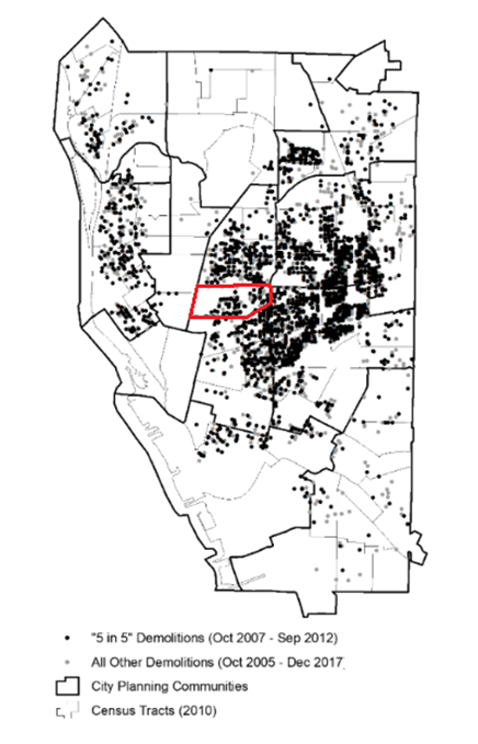
Cities across the Rust Belt have used a variety of federal and state funding to demolish as much blight as they could. Vacancy and abandonment are significant obstacles to stabilization, reinvestment, and revitalization at both the neighborhood and city level. The logic of demolishing these buildings is that if a city can remove what is being used for criminal activity or targets of arson, or that are otherwise draining the value of surrounding properties, investors will return to the neighborhoods.[18] In the City of Buffalo, the “5-in-5” program aimed to demolish 5,000 vacant and abandoned properties over five years starting in 2007.[19] 

Figure 5: Distribution of all public demolitions from October 2005 to December 2017

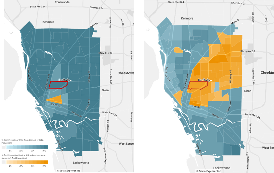
Figure 6: Fruit Belt & North Oak Neighborhoods: Aerial Photo 1951 v. Satellite Image 2022

Figure 5 shows that the Fruit Belt (outlined) was affected by the 5-in-5 demolition program. In figure 6 , the Kensington Expressway construction and North Oak’s disappearance aside, holes in the built environment left by waves of demolition have become obvious. There are now numerous empty lots in a neighborhood that used to be fully built out.

The history of the Fruit Belt is often told in two separate pieces. There are the German immigrants whose story is full of hope and optimism and there are the African Americans whose story is one of displacement and decline. The African American story has long gone ignored due to shame over years of systemic and systematic racism. The Fruit Belt, no longer orchard filled, has watched its neighbors change drastically. The construction of the Kensington Expressway cut it off from adjoining neighborhoods. HOLC maps colored it orange and ensured its discrimination. White Flight and continued population decrease left buildings empty to rot. Urban renewal projects like the demolition of North Oak have had far reaching consequences.

Today, the threat of gentrification looms over the Fruit Belt. Parking is at a premium despite its abundance of houseless lots. There is renewed demand for vacant properties throughout the neighborhood due to the growth of the adjacent Medical Campus but what will fill them? The current residents are being threatened with displacement yet again but they are not helpless. Inhabitants have created the Fruit Belt Community Land Trust. Community Land Trusts (CLTs) are nonprofit organizations governed by a board of residents and public representatives that aim to provide lasting assets and opportunities for households and the community. They acquire vacant land and structures to develop housing, gardens, and commercial space selling homes for a low cost that remain permanently affordable.[20] 


[1] “Segregated by Design,” accessed October, 2022, https://www.segregationbydesign.com/buffalo/freeways.

[2] Thomas J. Sugrue, The origins of the urban crisis : race and inequality in postwar Detroit, First Princeton classics edition. ed., Princeton studies in American politics: historical, international, and comparative perspectives, (Princeton: Princeton University Press, 2014).

[3] Mike Davis, Planet of slums, Paperback ed. (London ; New York: Verso, 2007).

[4] City of Buffalo Redevelopment Project for the Ellicott District Redevelopment Project,  (Buffalo City of Buffalo 1957).

[5] Intensive Level Survey Of The Fruit Belt, Buffalo, New York.

[6] Intensive Level Survey Of The Fruit Belt, Buffalo, New York.

[7] Kensington Expressway Arterial Improvement, Downtown Buffalo to Airport : via Cherry Street, Humboldt Parkway, Kensington Avenue, Maryvale Drive, Buffalo, New York,  (Buffalo 1953).

[8] Intensive Level Survey Of The Fruit Belt, Buffalo, New York.

[9] “U.S. Awaits Bid for Aid on Renewal,” Buffalo Courier-Express, August 17 1965.

[10] Angela Keppel, “North Oak: Urban Renewal and the Lost Neighborhood of the Medical Campus,” Discovering Buffalo, One Street at a Time, 2021.

[11] Rod Watson, ” Gentrifying of Fruit Belt Tastes Sour,” The Buffalo News 2015; Watson, ” Gentrifying of Fruit Belt Tastes Sour.”

[12] Avery Schnieder, “City, state and union leaders announce agreement on Fruit Belt neighborhood parking,” (https://www.wbfo.org/local/2016-05-14/city-state-and-union-leaders-announce-agreement-on-fruit-belt-neighborhood-parking 2016).

[13] Intensive Level Survey Of The Fruit Belt, Buffalo, New York.

[14] Intensive Level Survey Of The Fruit Belt, Buffalo, New York.

[15] Weaver, Shrinking cities : understanding urban decline in the United States.

[16] Hackworth, Manufacturing decline : how racism and the conservative movement crush the American Rust Belt.

[17] Russell Weaver, “Can Shrinking Cities Demolish Vacancy? An Empirical Evaluation of a Demolition-First Approach to Vacancy Management in Buffalo, NY, USA.,” Urban Science (2018).

[18] Hackworth, Manufacturing decline : how racism and the conservative movement crush the American Rust Belt.

[19] Weaver, “Can Shrinking Cities Demolish Vacancy? An Empirical Evaluation of a Demolition-First Approach to Vacancy Management in Buffalo, NY, USA..”

[20] “What is a Community Land Trust?,” Fruit Belt Community Land Trust 2022.

A Legacy of Segregation: Buffalo, NY’s Fruit Belt (Pt:2)

Federal Housing Policy, Redlining, & Discriminatory Lending 

A major instrument of discrimination to emerge was redlining. Prior to the New Deal, a typical mortgage required a considerable down payment of around half of the property value and needed to be repaid within a few years. In response to the mass foreclosures of the Great Depression, the National Housing Act of 1934 created the Federal Housing Agency (FHA)[1] to supplement the Home Owners’ Loan Corporation (HOLC), created in 1933.[2] The HOLC was a rescue program created to save households that were about to default on mortgages. It purchased existing loans that were close to foreclosure and issued new mortgages with extended repayment schedules upwards of 15 years. HOLC mortgages were also amortized, meaning when the loan was paid off the borrower would own the home.[3] The FHA, on the other hand, was to underwrite low-interest, long-term loans with low down payments to facilitate homeownership.[4]

As part of its development the FHA mapped all of the urban areas in the United States, including statistics like the percentage of foreign families, percentage of “Negros,” and indications of “shifting and infiltration.” With these factors in mind, neighborhoods were divided into several “grades” from first or ‘A’ to fourth or ‘D’. The ‘D’ grade neighborhoods were typically all or predominantly Black, given a low grade despite other factors that indicated stability. The HOLC did similarly using grades and colors. Red was the lowest grade or highest risk area which contributed to the moniker “redlining” decades later. This racially explicit grading system informed mortgage lending policy.[5] 

Figure 1: 1937 HOLC Map & 2019 Concentrated Disadvantage Map

In figure 1, the map labeled “Then” is based on an HOLC map of the city from 1937, showing both the actual as well as the interpolated grading with the juxtaposed map labeled “Now” based on 2019 conditions of concentrated disadvantage. Note that the Fruit Belt is graded ‘C’, or yellow, in the 1937 map and also yellow, or ‘C’, in the 2019 map. Together the maps show that the areas marked as grades ‘C’ or ‘D’ tend to have a higher concentration of disadvantage today than those that had been marked with higher grades in 1937 thus illustrating the long-term effects of redlining. 

Creating a positive feedback loop or cumulative causation, many neighborhoods, especially on the East Side of Buffalo, have been heavily impacted by redlining. The collective effect of sustained redlining has been the constriction of capital allotment in these spaces.[10] This means it was not poverty alone that made it difficult for African Americans to invest in their homes. It is unclear how much the HOLC itself is to blame but its maps were used in a way that led to an accumulation of discriminatory practices in the areas already identified as declining in the 1930s.[11]

White Flight

As early as 1930, a small group of African Americans lived in the Fruit Belt mainly clustered on the western side of Michigan Avenue. Between 1940 and 1970 over 70,000 African Americans poured into the City of Buffalo. By the 1950s, there was beginning to be a significant change in population composition in the Fruit Belt. The neighborhood was predominantly African American by 1970.[12] 

Table 1: Total Population; Total White & Black Population of Census Tract 31

Figure 2: Map of demographic majority (1950) v. Map of demographic majority (2020)

Table 1 shows a significant change in neighborhood demographics over a 70-year span. Figure 2 illustrates the difference in demographic distribution from 1950 to 2020; showing the white population of census tract 31 (outlined) as making up roughly 99 percent of the total population in 1950 and African Americans making up about 81 percent of the total population in 2020 by contrast. This census tract was chosen because it encompasses the Fruit Belt. It is not a perfect representation, however, as it includes what used to be the North Oak neighborhood to the west which, as will be covered, was destroyed by urban renewal.

The decline in total population should be noted as well. There was a significant decrease in the total population between 1970 and 1980. This coincides with the overall decline of the City of Buffalo and its deindustrialization. Where there had been nearly 53,000 manufacturing jobs the city lost almost 80% of its manufacturing base by 2009.[13] The population reached its peak in the 1950s at around 580,000 people, the combination of white exodus to the suburbs and loss of employment opportunities resulted in the City’s total population shrinking by nearly half over the next 60 years.[14]

The white outmigration hit the Fruit Belt hard. The thousands of African Americans moving into the declining East Side community did not offset the significant number of whites moving out and this mismatch produced a housing vacancy and abandonment problem.[15] In the Fruit Belt, most of the demolition of aged housing stock happened throughout the 1960s and 1970s and even into the 1980s.


[1] Blatto, A City Divided: A Brief History of Segregation in Buffalo.

[2] Richard Rothstein, The color of law : a forgotten history of how our government segregated America, First edition. ed. (New York ; London: Liveright Publishing Corporation, 2017).

[3] Rothstein, The color of law : a forgotten history of how our government segregated America.

[4] Blatto, A City Divided: A Brief History of Segregation in Buffalo.

[5] Blatto, A City Divided: A Brief History of Segregation in Buffalo.

[6] Edward W. Soja, Seeking spatial justice, Globalization and community series, (Minneapolis: University of Minnesota Press, 2010). Book review (H-Net) http://www.h-net.org/reviews/showrev.php?id=30986.

[7] Russell Weaver, Part 1 – Geographies of Discrimination, Cornell University (2019).

[8] Rothstein, The color of law : a forgotten history of how our government segregated America.

[9] Hackworth, Manufacturing decline : how racism and the conservative movement crush the American Rust Belt.

[10] Hackworth, Manufacturing decline : how racism and the conservative movement crush the American Rust Belt.

[11] Weaver, Part 1 – Geographies of Discrimination.

[12] Taylor, A Historical Overview Of Blacks In The Fruit Belt: The Continuing Struggle To Build A Vibrant Community.

[13] Robert Mark Silverman, “Dawn of the Dead City: An Exploratory Analysis of Vacant Addresses in Buffalo, Ny 2008–2010,” Journal of Urban Affairs (2016),https://doi.org/https://doi.org/10.1111/j.1467-9906.2012.00627.x.

[14] Silverman, “Dawn of the Dead City: An Exploratory Analysis of Vacant Addresses in Buffalo, Ny 2008–2010.”

[15] Henry Louis Taylor, The Harder We Run: The State of Black Buffalo in 1990 and the Present School of Architecture and Planning & U.B. Community Health Equity Institute (Buffalo 2021).

A Legacy of Segregation: Buffalo, NY’s Fruit Belt (Pt:1)

There is no single factor that fully explains all instances of urban decline and its symptoms.[1] Redlining, white flight, urban renewal projects, and demolition as urban policy have contributed to distress, concentrated disadvantage, and decline in the Fruit Belt by reducing total population, housing stock, and housing quality.  There were 200 years of German heritage in the Fruit Belt which has given way to 70 plus years of African American community building in the face of injustice.[2] Once the population in the neighborhood was over 15,000 people, over 90 percent white. Today, the Fruit Belt population is around 2,600, of whom 83 percent are African American.[3] The neighborhood has seen a lot, from drastic population loss to mass demolition and the African American story of the Fruit Belt has long been ignored.

Defining Urban Decline

Decline is a relative concept, meaning it is not a static variable that can be measured or evaluated at a single point. It is an active phenomenon that must be detected over time. Distress and disadvantage, on the other hand, geographers argue to be more static. Distress can be interpreted as “the degree to which a community is vulnerable to detrimental changes” while disadvantage is “a quality or circumstance that makes achievement unusually difficult.” Thus, a place with a higher concentration of disadvantage and distress is more threatened by decline.[4]

Fruit Belt

Germans arrived in Buffalo throughout the 1830s and 1840s and primarily settled east of Main Street. Eventually, “the Great German East Side” was home to over 14,000 Germans, making them a majority population in the city.[5] The Orchard, later known as the Fruit Belt, was not the first German settlement in Buffalo but it did end up being the last enclave. The neighborhood takes its name from the once abundant orchards that the first residents cultivated. Holding true to their agrarian roots, the earliest residents planted fruit trees and vegetable gardens, the street names remaining testimony to the early nature of the neighborhood.[6] After World War I, the German immigrants who had settled on the East Side began leaving.

The World Wars were a major blow for the German community, resulting in anti-German sentiments throughout the country. The prejudice that permeated American culture led many to begin to hide their heritage, which had previously been fundamental to the East Side. With the German population moving out, other working-class groups started moving in. By the mid-1920s, the Fruit Belt was the last neighborhood with a majority German population. Like many Rust Belt cities, during this time Buffalo went from being separated largely by class to experiencing high rates of racial segregation.

Throughout the Great Migration, from the 1910s to 1970s, many African Americans moved to the North from the South in search of employment opportunities. As a major manufacturing city, Buffalo would become a prime destination for those in search of jobs after World War II.[7] Many factors spurred black relocation to the Fruit Belt and its transition to a predominantly African American neighborhood including a series of urban renewal projects and the construction of the Kensington Expressway.[8] The new arrivals started to settle in white, working-class neighborhoods like those of the East Side. 


[1] Jason R. Hackworth, Manufacturing decline : how racism and the conservative movement crush the American Rust Belt (New York: Columbia University Press, 2019).

[2] “History of the Fruit Belt,” Fruit Belt Community Land Trust 2022, https://fruitbelt-clt.org/history-of-the-fruit-belt/.

[3] “History of the Fruit Belt.”

[4] Russell Weaver, Shrinking cities : understanding urban decline in the United States (London ; New York: Routledge, Taylor & Francis Group, 2017).

[5] Intensive Level Survey Of The Fruit Belt, Buffalo, New York, Preservation Studios (Buffalo, 2018), https://preservationbuffaloniagara.org/wp-content/uploads/Fruit-Belt-ils-report-final-1-4-2019.pdf#.

[6] The Fruit Belt: A Conservation District Proposal, University at Buffalo School of Architecture and Planning (Buffalo 2010).

[7] Anna Blatto, A City Divided: A Brief History of Segregation in Buffalo., Partnership For the Public Good (2018).

[8] Henry Louis Taylor, A Historical Overview Of Blacks In The Fruit Belt: The Continuing Struggle To Build A Vibrant Community, University at Buffalo Center for Urban Studies, School of Architecture and Planning (Buffalo, 2009), https://ubwp.buffalo.edu/aps-cus/wp-content/uploads/sites/16/2015/04/The-Rise-Fall-and-Rise-of-the-Fruit-Belt.pdf.

A History of Urban Parks

Urban parks, in the United States, have changed quite a bit since their inception playing an different, important roles in urban life. Many early parks began life as “commons”, a shared space/resource. There is a general belief that the Boston Common is the nation’s first or oldest park. Located in Boston, MA, it was purchased in 1634 and set aside to be public land by a vote in 1640. But what makes a park a park and not a commons? Definitions vary. One could argue that designated use dictates whether something is a park or not. I had this come up during my stint working for local parks and recreation when we had to define the difference between parks and zoned open space. The term “commons” is derived from the traditional English legal term for common land. Common land can be defined as “privately owned land over which other people have certain rights, such as to allow their livestock to graze upon it, to collect wood, or to cut turf for fuel.” These uses would definitely not fly in parks today nor would they have in parks during the late 1800s, often referred to as “pleasure gardens”.

Pleasure gardens typically consisted of an ornamented landscape composed of lawn, trees, shrubs, flowers, intersecting walks, and decorative structures. These were the first incarnation of what we, today, would think of as parks in the US with some distinctions. The pleasure garden period lasted roughly from 1850 to 1900 and were typically large and located on the edge of a city as it was difficult to plop a bit of “wilderness” into an already established urban fabric. “Meadows accommodated picnicking families and church groups. Rowing on ponds provided a pleasing contrast to urban routings. Open meadows and sequestered rambles were laid out for strolling. Benches encouraged people to stop and look at others on parade.” Many activities specifically associated with lower classes and immigrants were banned which, paired with their locations away from city centers, meant that, though parks were intended to be used by everyone from the start, they largely appealed to the upper-middle class.

During the early 1900s the vision for urban parks started to change. Thanks to the larger reform movement of the Progressive Era, reform parks were born. The longest lasting feature of which is the neighborhood playground but they also introduced field houses. A field house was a sort of club house for neighborhood residents. “Progressives interested in neighborhood reform argued that recreational needs should be met daily at nearby sites, rather than on occasional outings to the city’s outskirts.” The typical neighborhood park was one or two square blocks surrounded largely by housing. Paths in the reform park was frank and straightforward featuring right angles, grass pushed out by sand and blacktop.

By the mid-1900s the divide between recreation and the park was in full swing. The “recreation facility” was created. It was at this time that parks were recognized as a functioning part of cities. Athletic leagues were being organized including sports like: softball, tennis, table tennis, basketball, and golf. The idea of “togetherness” was rekindled and all reference to class issues was abandoned replaced by discussions of efficient management and “service to the community”.


Beveridge, Charles E. 2000. “Olmsted—His Essential Theory”. Olmsted.Org. https://www.olmsted.org/the-olmsted-legacy/olmsted-theory-and-design-principles/olmsted-his-essential-theory.

“Common Land”. 2014. Webarchive.Nationalarchives.Gov.Uk. https://webarchive.nationalarchives.gov.uk/20140605104731/http://www.naturalengland.org.uk/ourwork/landscape/protection/historiccultural/commonland/default.aspx.

Cranz, Galen. 2000. “Changing Roles Of Urban Parks”. SPUR. https://www.spur.org/publications/urbanist-article/2000-06-01/changing-roles-urban-parks.

Cranz, Galen. 2008. “Urban Parks Of The Past And Future”. PPS. https://www.pps.org/article/futureparks.

“Parks, Parkways, Recreation Areas, And Scenic Reservations – Frederick Law Olmsted National Historic Site (U.S. National Park Service)”. Nps.Gov, 2022. https://www.nps.gov/frla/learn/historyculture/parks.htm#:~:text=Olmsted%20believed%20that%20in%20a,gathering%20and%20entertainment%20of%20crowds.

Walls, Margaret. 2009. “Parks And Recreation In The United States: Local Park Systems”. Resources For The Future. https://www.rff.org/publications/issue-briefs/parks-and-recreation-in-the-united-states-local-park-systems/.

Until Justice Be Done

cover of Until Justice Be Done: America's First Civil Rights Movement from the Revolution to Reconstruction by Kate Masur
Until Justice Be Done: America’s First Civil Rights Movement from the Revolution to Reconstruction by Kate Masur

Kate Masur highlights the fundamental difference between the anti-slavery and the Civil Rights movements reaching backward from the Reconstruction through the early American republic. Masur emphasizes police powers of the states and the poor law traditions as rivals to the tradition of individual rights shining light on the decades long making of the 14th amendment.

The Second

Cover of Carol Anderson's book, The Second: Race and Guns in a Fatally Unequal America
The Second: Race and Guns in a Fatally Unequal America by Carol Anderson

In her book, The Second, Carol Anderson provides an overview and examination of the racially rooted popularity of the Second Amendment, outlining the hypocrisy of the people that defend it. Anderson highlights the consistency with which Blacks’ Second Amendment rights have been denied throughout US history from slave codes to Jim Crow and beyond. It’s quick and concise and I highly recommend the read.

Protesting the Black Codes: The Streetcar

Before we dive in, a brief descriptor of “Black Codes.” They were restrictive laws that were designed to limit the freedom of African Americans. Largely, they were created as a way to the continued availability of a cheap labor force after slavery was abolished. This set of laws was applied blanketly to both freemen of color and freedmen; that is, those that were born free before the Civil War and those that were freed after it. Around four million African Americans had been given their freedom but the postwar South left many questions surrounding their social status. This lead to the creation of the Black Codes which, in many places, required Black people to sign yearly labor contracts or, for the previously free people, even find white sponsors to vouch for their character. Failing to comply with these codes meant arrests, fines, or even being forced into unpaid labor. (Pictured above: A free Black man being sold to pay his fine. Monticello, FL, 1867. ) Again, these codes were indiscriminately applied to all black people including those that were biracial and/or were freemen before the war; this will be important in a moment.

Contrary to popular belief, there were integrated areas antebellum. These places, namely New Orleans, LA, and Charleston, SC, saw color lines blurred quite openly. A person of even the darkest complexion could have all the rights of a white person based on their family ties rather than their skin color. That was, however, when New Orleans was controlled by France and Spain and Charleston still had strong ties to the Caribbean. It wasn’t until the Union took over these places during the Civil War that the old racial binary was truly enforced. Freemen and freedmen were lumped together as “Blacks” and the people that were born free antebellum lost a great deal of privileges as the “one drop rule” became prevalent. The “one drop rule” was the thought that a single “drop” of African American blood made one wholly Black in the eyes of the law and society. There were groups of mixed race people that formed in an effort to fight to regain their lost rights like the Brown Fellowship Society in Charleston and the Creoles of Color or Gens de couleur libres (free persons of color) in New Orleans. There is a lot of interesting history surrounding these groups, their creation, and their fight for equality but that’s for a whole other post. The important part for now is that they existed and, antebellum, enjoyed the rights of full citizens.

When most Americans think of civil rights laws and protests they likely think of the 1950s and ’60s. We all know the story of Ms. Rosa Parks’ and the Montgomery Bus Boycott that ensued but the story of transportation integration really began in the 1860s. Streetcars had been an issue for people of color in New Orleans since their implementation in the 1820s. A few rail companies operated Black-only cars sometimes demarcated with a black star. However, “Star Cars”, as they came to be known, were few and far between. After the Union occupation of New Orleans in 1862, General Benjamin F. Butler ordered that the streetcar lines be desegregated but rail companies complained and it didn’t stick. Butler’s successor, Major General Nathaniel P. Banks, was able to persuade the rail companies to allow African American soldiers to ride white-only streetcars in 1864 but this did little to help other African Americans. One spokesman is quoted as saying it was “a shame that a colored solider be received in the cars, and his mother be expelled.”

In 1865, there was some progress made, at least temporarily, when General E. R. S. Canby, Banks’ superior, issued an order that stated that “the attempt to enforce police laws or regulations that discriminate against negroes by reason of color, or their former condition of slavery…will not be permitted.” In essence, this made all streetcars fair game for whomever wanted to ride them, star or no. Unfortunately, the rail companies took to the courts and, a mere two weeks later, the edict was nullified as it “infringed upon the basic right of a private corporation to refuse service to any group or individual it desired.” Then came the Civil Rights Act of 1866, one year postbellum, which declared that all people (males at least) born in the United States were thus citizens and had certain inalienable rights and enjoy the full protection of federal law without distinction of race, color, or previous condition of slavery or involuntary servitude. One might think that this would aid in the fight for streetcar equality as the star cars were incompatible with the Act.

Alas, the streetcar segregation controversy continued coming to a head during the spring of 1867 when it became the focal point of racial unrest. Fearing a race war, federal authorities asked anyone who felt their rights had been violated to file a formal complaint. Such a complaint was filed with the Freedmen’s Bureau on April 17 by Mary P. Bowers, an African American Charlestonian, when she was asked to leave a whites-only car despite claiming that she had ridden such cars many times before. Little is known about Bowers but it seems likely that, based on her claims and description, she was mixed-race and born free antebellum and had enjoyed the privileges that came with that. It was also likely that she had been chosen by local activists to make a test case in the courts to force the Reconstruction authorities’ hand. The following Monday, a representative of the Freedmen’s Bureau wrote to the president of the Charleston City Railway Company informing him that “public carriers have no right to exclude individuals from their conveyances on account of color.” The company stalled for time citing court cases in other Southern cities that ultimately ended with the creation of star cars but such half-measures wouldn’t fly.

Frustrations were growing in New Orleans as they followed the news out of Charleston. On April 28, William Nichols, an African American man in New Orleans, took a seat upon a whites-only streetcar. He was physically removed from said seat by Edward Cox and arrested for “breach of peace.” The charges were dropped and Nichols took Cox to court, suing him for assault and battery. The rail companies, determined to retain segregation, but also eager to avoid lawsuits, settled on a policy of “passive resistance.” Streetcars boarded by Black riders would simply stop, and drivers were ordered to wait the activists out. This new policy was tested by P. Ducloslange, a Creole of Color, on May 3 when he boarded a whites-only car and refused to budge. The driver, as instructed, refused to move as well which resulted in an hours-long endurance battle that left just the two men on the car. Eventually, Ducloslange gave in and left the car; empty but victorious, the car started on its way again. That wasn’t the end of the protests though, that weekend would see more.

As long as the star cars rolled, the chance of protest loomed over any whites-only streetcar that dared to enter the Creole wards. The Friday after the passive resistance policy was adopted, Joseph Guillaume, young Creole of Color, boarded a whites-only car and, upon being told to leave, he stole the reins of the horse drawn streetcar and drove it down the street himself. (Pictured above: A horse drawn streetcar in New Orleans.) Guillaume was eventually cornered and taken into custody. A mob grew, “squads of colored men, fifteen or twenty in a gang, armed with clubs” a police officer reported, jumping on passing cars and threatening their drivers.

In Charleston, on May 3, the Charleston City Railway Company’s board of directors gathered passing a resolution that “the cars be thrown open to the public, and that instruction be given to the several conductors to recognize the right of all persons to ride therein.” On Sunday, May 5, the unrest in New Orleans came to a head. Despite threats made against the streetcars, the rail companies kept them running. Roughly 500 protesters began to amass on Congo Square, the main African American public space, taking up positions on either side of Rampart Street. As star cars came by, the protesters encouraged riders of color to get off and join them. When whites-only cars showed up African American riders hopped aboard. The police finally came brandishing weapons to intimidate the crowd. This is when the mayor, Edward Heath, appeared and tried to calm the protestors stating that there was no need for violence, peaceful protest is the right of every American citizen.

The next morning, the presidents of the various companies met to discuss next moves. Major General Philip Sheridan, federal official, gave the executives an ultimatum: “Erase your stars and make all your buses open to all.” With the previous night’s unrest fresh in their minds, they saw little alternative but to cave in to the demands. Hours later, the official word was out that the streetcars would now be open to everyone. When Nichols arrived in court that Wednesday his case was already won and there was no need to move forward so he dropped the charges. Within days, the stars on the star cars had been painted over. In Charleston the change seemed to happen and be accepted overnight. In New Orleans, however, it was a little slower going as Black riders still seemed to segregate themselves (supposedly) though white riders were said to have taken to the change rather quickly (supposedly). Success! But it was not to last, bills to segregate cars were defeated in 1894 and 1900 but they were desegregated by state law in 1902 this time by moveable screens within the same car.


Bardes, John. 2018. “The New Orleans Streetcar Protests Of 1867”. We’re History. https://werehistory.org/the-new-orleans-streetcar-protests-of-1867/.

Brook, Daniel. 2019. The Accident Of Color. New York: W. W. Norton & Co.

Fischer, Roger A. “A Pioneer Protest: The New Orleans Street-Car Controversy of 1867.” The Journal of Negro History 53, no. 3 (1968): 219-33. Accessed May 28, 2021. doi:10.2307/2716217.

Gates, Henry Louis. 2019. Stony The Road. Penguin Publishing Group.

“How The Black Codes Limited African American Progress After The Civil War”. 2021. HISTORY. https://www.history.com/news/black-codes-reconstruction-slavery.

The Green Book

The Green Book, also know as the “The Negro Motorist Green Book”, was created by an African-American, New York City mailman named Victor Hugo Green. It was published from 1936 to 1966, during the era of Jim Crow laws. Throughout this time, discrimination against people of color, specifically African Americans, was conspicuous and often legally backed. Green’s book aimed to aid marginalized groups find inclusive businesses and avoid discrimination, and often danger, on their travels. Segregationist practices meant that facilities for African-American motorists were limited. So, it provided a rundown of hotels, guest houses, service stations, drug stores, taverns, barber shops, and restaurants known to be safe for travelers of color. The book also helped people avoid Sundown Towns, municipalities in which Blacks could not remain after dark.

To be brief about Jim Crow Laws, they began around 1865 after the ratification of the 13th Amendment, which abolished slavery in the United States. Also known as “Black codes,” these were strict local and state laws that determined when, where, and how formerly enslaved people could work and how much they could be paid.. They were a legal way to put Black citizens into indentured servitude, take voting rights away, and control where they lived and how they traveled.

Green was likely inspired by earlier publications for Jewish audiences, who also faced discrimination. The first edition the book covered only the New York City area. Soon the book expanded by, brilliantly, gathering field information from fellow postal carriers and readers. In a few years, the Green Book was host to thousands of establishments across the country, all either black-owned or verified non-discriminatory. Eventually, the Green Book expanded from a motorists’ companion to an international travel guide as later editions included information on airline and cruise ship journeys to places like Canada, Mexico, the Caribbean, Africa and Europe.

Victor Hugo Green died in 1960. His wife, Alma Green, took over as editor and continued to release the book. In 1964, the Civil Rights Act banned segregation in restaurants, theaters, hotels, parks, and other public places rendering the Green Book essentially obsolete, just as Green has hoped would eventually happen.

“There will be a day sometime in the near future when this guide will not have to be published. That is when we as a race will have equal opportunities and privileges in the United States. It will be a great day for us to suspend this publication for then we can go wherever we please, and without embarrassment.”

Introduction to 1948 edition of the “Negro Motorist Green Book”

Today, the Green Book is back in the form of an app called The Green Book Project. The app allows users to share their experiences of businesses, filter by intersections, post alerts when things are unsafe, and support inclusive business owners. It is unfortunate that such a thing should have to exist but I’m glad that people are looking out for one another. There is also a effort to save locations mentioned in the Green Book.


AuMaroc, J. How the Green Book Helped African-American Tourists Navigate a Segregated Nation. Smithsonian Magazine. Retrieved 7 March 2021, from https://www.smithsonianmag.com/smithsonian-institution/history-green-book-african-american-travelers-180958506/.

Jim Crow Laws. HISTORY. (2018). Retrieved 8 March 2021, from https://www.history.com/topics/early-20th-century-us/jim-crow-laws.

The Green Book Project. The Green Book Project. Retrieved 7 March 2021, from https://www.thegreenbook.io/?.

The Green Book: The Black Travelers’ Guide to Jim Crow America. HISTORY. Retrieved 7 March 2021, from https://www.history.com/news/the-green-book-the-black-travelers-guide-to-jim-crow-america.

The Green Book: The Black Travelers’ Guide to Jim Crow America. HISTORY. Retrieved 7 March 2021, from https://www.history.com/news/the-green-book-the-black-travelers-guide-to-jim-crow-america.

The Negro Motorist Green Book. En.wikipedia.org. Retrieved 7 March 2021, from https://en.wikipedia.org/wiki/The_Negro_Motorist_Green_Book